 missoulamarathon.org >>
Run Wild Missoula
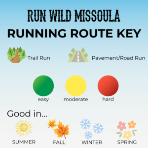
Running Routes
Where to Run in Missoula, Montana
Missoula is a runner’s dream—where mountain views, fresh air, and an incredible network of trails come together. With over 60 miles of scenic singletrack winding through surrounding hills, along rivers, and into nearby wilderness, there’s no shortage of places to explore. Prefer something smoother? The city also offers more than 50 miles of paved trails, along with well-maintained parks, perfect for runners, walkers, and families alike. Whether you’re chasing elevation or enjoying a relaxed stroll, Missoula makes it easy to get outside and keep moving.


The iconic M Trail is one of Missoula’s most recognizable and beloved routes, climbing the slopes of Mount Sentinel just minutes from downtown and the University of Montana campus. Known for its steady switchbacks and rewarding views, this short but challenging climb is a favorite for runners, hikers, and visitors looking to experience a true Missoula classic. As you make your way up to the famous “M,” you’ll be treated to sweeping views of the Clark Fork River, surrounding mountains, and the entire Missoula Valley. Whether you’re squeezing in a quick workout or checking off a local landmark, the M Trail offers a quintessential Montana trail experience close to the heart of town.
It is approximately 0.8 miles up to the “M” for a total round trip of ~ 1.6 miles.
See Strava link for details.
A favorite among Missoula locals, this route starts at the iconic M Trail before climbing steadily past the “M” on long, wide switchbacks to the summit of Mount Sentinel. The effort is well worth it — at the top, runners are rewarded with breathtaking panoramic views of the Missoula Valley and surrounding mountain ranges. From there, the route follows the Hellgate Ridge ridgeline for a more technical and adventurous descent, featuring rugged terrain and classic Missoula singletrack. Best suited for experienced trail runners, this route is perfect for anyone looking to combine a solid climb, and some of the best views in town.


Interested in getting a feel for Missoula’s college-town atmosphere? This loop starts near the Adams Center on the University of Montana campus and takes you right through the heart of campus for a self-guided tour. From there, you’ll explore the tree-lined streets of the University District and pass through one of our team favorites, Bonner Park. The route finishes along the beloved Kim Williams Trail, with beautiful river views the whole way.
Looking to add a few extra miles? Wander through the University District side streets or continue farther along the Kim Williams Trail to extend your run.
See Strava Link for route details.
The Kim Williams Trail is Missoula’s river trail. Spanning from East Missoula to the heart of town, it’s a perfect way to enjoy the Clark Fork River, campus life, and downtown.
As a paved trail, it’s great year-round—especially for a quick river splash after a hot summer run. Extend your run west on the Milwaukee Trail or south on the Bitterroot Branch Trail.
See the Strava link below for our favorite downtown–Kim Williams out-and-back route. It’s perfect for a pre- or post-flight shakeout, an after-dinner stroll, or a lunchtime workout.
The Bitterroot Branch Trail is a paved connector that makes it easy to link runs through the heart of Missoula. With its flat, smooth surface, it’s perfect for easy miles, quick workouts, or adding distance to a larger route. While more urban than scenic, it offers reliable footing and convenient access year-round. From downtown Missoula, you can connect to the Bitterroot Trail and follow it all the way to Lolo, MT and beyond—check out the Strava link for a full overview of the route.
This route is perfect when you need a little breather from the hustle and bustle of town. Fort Missoula is a large recreational park with plenty going on—baseball, soccer, rugby, pickleball, and even a dog park—so there’s always some energy around.
The run starts at the far west parking lot on the west side of the soccer fields and loops through the Target Range neighborhood. You’ll get a short stretch of gravel to mix things up a bit, which adds some nice variety.
It’s a great option for a relaxed weekend run and can easily be extended further into the Target Range area if you’re looking for more mileage. Just be sure to stay on the left side of the road and keep an eye out for cars.
Check out the Strava link for the full route.
Check out this Strava Link for a shorter loop around the Fort Missoula Recreation Area
Starting at Big Sky Park — home of our Dogs Days Ultra — this route explores the neighboring gravel trails winding through the Department of Natural Resources and Conservation (DNRC) Campus. Perfect for beginner trail runners, it offers an approachable introduction to unpaved running while staying close to the heart of Missoula. Along the way, you’ll enjoy sweeping 360-degree views of the Missoula Valley, gentle rolling terrain, and a welcoming community atmosphere. Keep an eye out for plenty of adorable four-legged friends, too — this area is a favorite for local dog walkers and runners alike!
Starting from the Bluebird Preserve trailhead, this scenic loop offers one of Missoula’s most accessible and peaceful trail experiences. Winding through open grasslands, and rolling singletrack, the Bluebird Trail Loop is a favorite for runners looking to enjoy nature without venturing far from town. With gentle climbs, flowing descents, and stunning views of the Missoula Valley, this route is perfect for beginner and intermediate trail runners alike. Keep your eyes open for blooming wildflowers in the spring, and plenty of wide-open Montana skies along the way!
Grant Creek Trail is a paved out-and-back route on the way up to iconic Snowbowl. Expect a gradual incline on the way out and a smooth, gentle downhill on the return. At about 6 miles total, it’s a great option for a quick workout while enjoying ranchland and mountain scenery just outside of town.
Check out the Strava link for the trail location.

Tucked into the Lincoln Hills area of Missoula, the Sound of Music Trail is a local favorite known for its smooth singletrack, rolling climbs, and breathtaking views overlooking the city and surrounding mountains. This route offers a fun mix of shaded forest sections and open hillside running, making it a great option for runners looking to experience classic Missoula trails close to town. The Sound of Music Trail delivers peaceful scenery, fresh mountain air, an abundance of beautiful wildflowers in the spring, and plenty of opportunities to stop and take in the view.
This route starts at the Lincoln Hills trailhead.
See Strava link for route details.
*Please note this trail is only open May – November. The winter closure is to protect wintering elk herds in the North Hills region of Missoula.*
This route is an easy hybrid of pavement and trails. Starting at Greenough Park, you’ll head up Duncan Drive — fair warning, it’s a sneaky false flat that feels longer than it looks! From there, the route loops over to Tom Green Memorial Park on some smooth, scenic trail. After winding down a few quiet neighborhood streets, you’ll finish back in Greenough Park with a beautiful stretch of wooded trail alongside the creek. A true Missoula classic.
See Strava link for route details.
The Sunlight Loop is one of Missoula’s gems for trail runners—a fast, flowing singletrack tucked into the North Hills with wide-open views of the valley and just enough climbing to get the legs working. Starting from the Peas Farm gravel lot, the route rolls steadily uphill before weaving along grassy ridgelines and descending beneath the powerlines back toward town. The terrain is runnable nearly the entire way, making it a favorite for quick lunch loops, easy aerobic days, or sunset shakeouts. Expect smooth dirt trail, rolling hills, and classic Missoula scenery.
Bonus: On hot summer days you can take a dip in the Rattlesnake Creek post run!
See Strava link for details.
This Waterworks loop is a classic. Steady climbs, smooth singletrack, sweeping ridgeline views, and long runnable descents. Starting on the Mountain View Trail, the route climbs gradually through open grasslands and pine-covered hillsides before connecting to Homestead Trail, where the terrain opens up with expansive views of the valley and surrounding peaks. From there, North Ridge Trail rolls along the spine of Waterworks Hill with fast, flowing sections that reward strong climbing legs and keep the pace fun from start to finish.
Expect winding dirt singletrack, exposed ridges, occasional wildlife sightings, and some of the best panoramic views in Missoula—all just minutes from downtown.
See Strava link for details.
Bonus: Looking for more mileage? Connect this route with the “Sunlight Loop” route.
The Woods Gulch Loop is a moderately challenging route with sustained climbs, rewarding descents, and beautiful views throughout the Rattlesnake foothills. Nestled in the Rattlesnake Recreation Area, this loop winds through shaded pine forests, open ridgelines, and rugged Montana terrain that feels surprisingly remote for being so close to town.
Whether you’re trail running, or hiking Woods Gulch offers a little bit of everything: steady climbs, fast descents, wildlife sightings, and panoramic overlooks of the Rattlesnake Wilderness and Missoula Valley. In spring and summer, wildflowers line the trail and the creeks run high; in fall, golden larches and crisp mountain air make it one of the area’s favorite shoulder-season routes.
The loop is known for its peaceful atmosphere and flowing terrain — challenging enough to feel like an adventure, but accessible enough for a strong half-day outing.
See Strava link for details.
The Wallman Trail is one of the Rattlesnake Recreation Area’s gems — a quiet, scenic route that offers a perfect mix of forested climbing, winding singletrack, and expansive views above Missoula. Tucked into the lower Rattlesnake foothills, the trail meanders through stands of pine and fir before opening to sunny hillsides and sweeping vistas of the valley below.
The steady climbs and rolling terrain make for a moderately challenging outing, while the smooth descents and flowing trail reward the effort along the way. Wildlife sightings are common, and the changing seasons bring everything from spring wildflowers to vibrant autumn colors.
See Strava link for details.